BACKGROUND ON PHOTO:
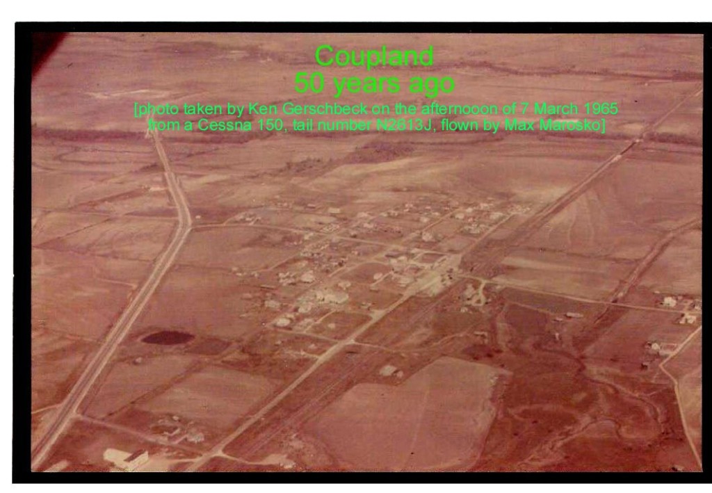
In the early afternoon of 7 March 1965, I rented a Cessna 150 from the Longhorn Flying Club at the Austin Mueller Airport to fly around the local Coupland area and asked Kenny Gerschbeck, a good friend from high school days, if he wanted to ride along, which he did.
As I recall, when this photo was taken, we were flying in a westerly direction (note the Cessna 150’s high wing strut in the photo’s upper left hand corner) at around 1500 ft MSL when Kenny took the photo out of the right side window of the airplane. North is to the upper right corner of the photo. I do not recall what type of camera Kenny used but it was probably a Kodak Instamatic. The photo in this story is a scanned copy of that photo.
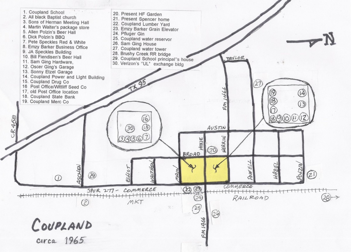
To help make sense of the photo and not clutter it up with notations, I have included (below) a hand drawn map of Coupland on that day. In 1965, the current “911” addresses had not yet been assigned; although no one used street names back then, those used below are from the original town plat and are the same as used today by 911.
COUPLAND, CIRCA 1965:
In that light, I’d like to call your attention to some of what you are looking at in the photo. Perhaps the first thing you may notice is that the west end of Hoxie St terminates at Austin St — no Stock Up, no Hoxie St access to TX 95, no Post Office building, etc. Also, Broad St “stops” at Elliot St — at that time, kids living less than (as I remember) 2 miles from the school were not entitled to bus service, so had to walk or be otherwise taken to school. You will notice a N-S path from the corner of Elliot and Broad to the school grounds that was maintained by the school board for the “town kids” use. Before TX 95 bypassed Coupland, Commerce and Herrin Streets were part of TX 95 and the footpath was used to keep the kids away from/off TX 95 and was kept in use after the bypass was completed. You will also notice that the current houses in that “Muery Addition” are non-existent. The house just north of the school was the school principal’s residence – at one time, the house was provided “in-kind” as part of the principal’s salary. I don’t recall when the school board sold the property.
If you follow what is now Spur 277/Commerce Street from near its southern beginning north into “town” you will notice that the school is just one large “T” shaped building, not the cluster of buildings it is today. What is the auditorium/gym was originally a WW2 military barracks at Camp Swift (near Bastrop), which was purchased and moved to Coupland. It was then connected to the west side of the original school building. Across the railroad to the northeast of the school is a black congregation Baptist Church that burned down at a later date that I don’t recall.
Continuing north, the “business district” was comprised basically of 2 blocks centered, more or less, on Hoxie St. In 1965, starting at the corner of Main and Commerce and moving north, on the west side of Commerce (where Manville offices are now) would be the Sons of Herman Meeting Hall, followed by Martin Walther’s “package” (liquor) store, Allen Polzin’s beer hall, Dick Polzin’s BBQ stand (open Saturday mornings only), the east side of Pete Speckles’ Red and White Grocery (really a general merchandize store). Going across Hoxie, I believe the building that housed the Post Office for many years may have been already torn down (can’t tell in the photo) but there was a building on that NW corner of Commerce and Hoxie that is no longer there which once housed Dick Polzin’s meat market and, when the photo was taken, it was the business office for Emzy Barker’s grain and trucking enterprises. Continuing north, next would be the JA Speckles Building that housed Ted Wittliff’s seed corn business (now serves as a “warehouse residence”), followed by Bill Fiendisen’s beer hall, Sam Ging Hardware store, and Oscar Ging’s Texaco service station and garage on the SW corner of Commerce and Herrin. There may have been another business along there that escapes me now. Going around the corner heading west on Herrin, was Sonny Etzel’s Gulf service station and garage on the south side of the street. Sonny Etzel may have closed his business by 1965; I don’t recall the exact date he closed. The building is still there. The next building west at one time housed the Coupland Power and Light Company into the 1930s when the company was sold to Texas Power and Light, which has since evolved into today’s TXU.
On the east side of Commerce opposite the Sons of Herman meeting hall and Allen Polzin’s beer hall was Coupland Lumber Yard, owned and operated by Arnold Marosko. Just north of the lumber yard, Emzy Barker had constructed a grain elevator where earlier there had been a large, wooden loading dock for the railcar shipment of locally ginned cotton bales.
East across the railroad track was the Pfluger Cotton Gin. Slightly east from the gin, along south side of FM1466, you may notice a water impoundment. That was the source of water for the original Coupland Water Supply Co. prior to its purchase by Manville. Water captured from that tributary of Brushy Creek was pumped from there up to a water tower on top of the hill near the corner of Powell and Taylor Streets for the gravity flow system. The concrete foundations for both the tower and associated treatment plant/equipment are still there.
There are several examples in Coupland of “Sears Modern Homes” which were sold by Sears Roebuck and Co. in the late 1890s and 1900s as precut lumber shipped by railcar from sawmills in Missouri. One of these is in the photo. It was the Sam Ging home that is shown on the north side of eastbound FM1466 just east of the first bridge – the house burned down sometime after the photo was taken but I don’t remember the date. [Editor’s note: The Sears Catalog was the original Amazon. See additional information at the end of the article.]
Going west bound on Hoxie St from its intersection with Commerce St, on the south side there would be the front of Speckles Red & White grocery store, followed by Coupland Drug Store and then the Post Office in the upper front part of the 2-story brick building with more of Ted Wittliff’s seed corn processing in the rear. The upstairs of that building was vacant for all intents and purposes. The depot had not yet been salvaged from being used as a hay barn out on a farm and resurrected at its current location, displaced some distance from its original site adjacent to the railroad tracks.
The telephone exchange building is seen behind the 2-story brick building. It is the same exchange that is in use today. In 1965, Coupland’s prefix was Ulrich 6, i.e., UL6 followed by 4 digits, which translates into the all digital 856 prefix we use today.
Opposite Speckles Red & White was a long tin-corrugated metal building, where the Post Office had been prior to moving across the street, and Barker’s office on the corner that I referenced above. Continuing west up the hill was the Coupland State Bank, which has evolved into a branch of Citizens National Bank just east of the original location. The original building is now a residence. The Post Office moved into that bank building after the new bank was constructed where the referenced tin building had been. West of and next door to the bank was the Coupland Mercantile Co. building. After the Coupland Mercantile Co (which was sort of an early Wal-Mart, selling groceries, men’s and women’s’ apparel, bulk dry goods, shoes, livestock feed and bought farm commodities in return) closed in 1954, the building housed several different enterprises, perhaps the longest lived of which was as a honey processing plant and business. Sometime later, John Thompson fabricated steel structures in it and then built (and added on to) the large metal building upon what had been a parking lot. Jim Huntington had this for a time as his sculpture studio. It now houses MD Floors. You will notice that where the Huntington Sculpture Garden is now located, there is a structure but I don’t recall what it was.
If you look closely at the north end of Commerce Street, you will notice a road along the west side of the railroad. This was the road the MKT used to service its Brushy Creek railroad bridge complex and is shown as such on early topographic maps of the area. The railroad bridge crews now go along the eastside of the railroad. You will notice a light colored area on both ends of the Brushy Creek slough bridge. Originally, the bridge was fully again as long to the south as it is in the photo and the bridge continued all the way to the north side of Brushy Creek. As a consequence of derailments on the bridge, the MKT filled in part of the south end of the slough bridge (twice) and filled in the bridge on the south bank of Brushy Creek, which accounts for the light colored material. The way you see it in the photo is pretty much how it is today.
I have tried to keep this narrative relevant to just 1965 but on occasion I have included some additional history/background to hopefully add clarity without going into great detail throughout. In that same vein, I have not updated most changes since the photo was taken except where I thought it helped visualize the picture better.
That’s probably more than you ever wanted to know about/from a 50-year-old aerial photo of a tiny burg in Central Texas but I hope you found the trip down memory lane of some passing interest.
********************************************************************************
Additional Information about Sears:
Richard Sears and Alvah Roebuck founded Sears, Roebuck, and Co in 1881 as a mail order catalog selling watches and jewelry. The Sears Roebuck catalog evolved into a lifeline of commerce for farmers, their families and small rural town residents. By 1897, the Sears Roebuck Catalog featured 700 pages advertising almost everything to fill a house, as well as tools and hardware. Soon, it offered the house itself. Home blueprints, hardware, and precut lumber for “Sears Modern Homes” was shipped nationwide from Missouri saw mills via railcar. Some 70,000 such houses were shipped, at least three of which were assembled here in Coupland. Two are still in existence. (Reference: March 2014 issue of Successful Farming magazine.)


Please don’t sell yourself short. I’m sure all us history fanatics read your detail with deep interest. Thank you so much. The included reference to Emzy Barker is or great interest too.